1) Executive Summary
PineVT Robotics Research Institute is launching a strategic collaboration with U.S.-based academia and industry to develop and deploy a long-endurance, VTOL (Vertical Take-Off and Landing) unmanned aerial system (UAS) designed for disaster monitoring. The platform integrates LEO (Low-Earth Orbit) satellite communications for resilient, beyond-line-of-sight (BLOS) operations and real-time data delivery when terrestrial networks are degraded or unavailable.
Program Goal: Deliver a field-proven VTOL system and cloud analytics stack capable of 18–24+ hours endurance, persistent ISR (Intelligence, Surveillance, Reconnaissance) coverage, and live data links via LEO satellites for national and international disaster response stakeholders.
2) U.S. Collaboration Program Overview
- Partner Types: U.S. universities (aeronautics & autonomy), satellite communications providers (LEO), emergency management agencies, and UAS manufacturers/integration labs.
- Collaboration Model: Joint R&D (TRL 5→8), shared test ranges, data-sharing agreements for disaster scenarios, and interoperability pilots with U.S. responders.
- Workstreams:
- Airframe & Power — endurance optimization and hybrid-electric propulsion.
- Satcom & Networking — LEO backhaul, adaptive routing, and multi-link redundancy.
- Autonomy & Safety — BVLOS capabilities, DAA (Detect-and-Avoid), and health monitoring.
- Sensing & AI — multi-sensor fusion, onboard AI for event detection.
- Cloud & Analytics — edge-to-cloud pipelines, mapping, alerting, and API services.
3) Use Cases in Disaster Response
- Wildfire Monitoring: Real-time perimeter growth, hotspot detection, smoke plume modeling.
- Floods & Storms: Levee breach detection, water-level mapping, rapid damage assessment.
- Earthquakes & Landslides: Infrastructure assessment, road blockage identification, survivor localization support.
- Maritime Incidents: Oil spill mapping, SAR (Search and Rescue) coordination over coastal regions.
4) System Architecture
Airframe (VTOL):
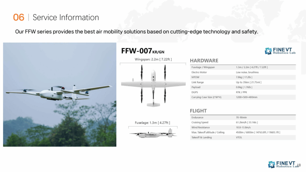
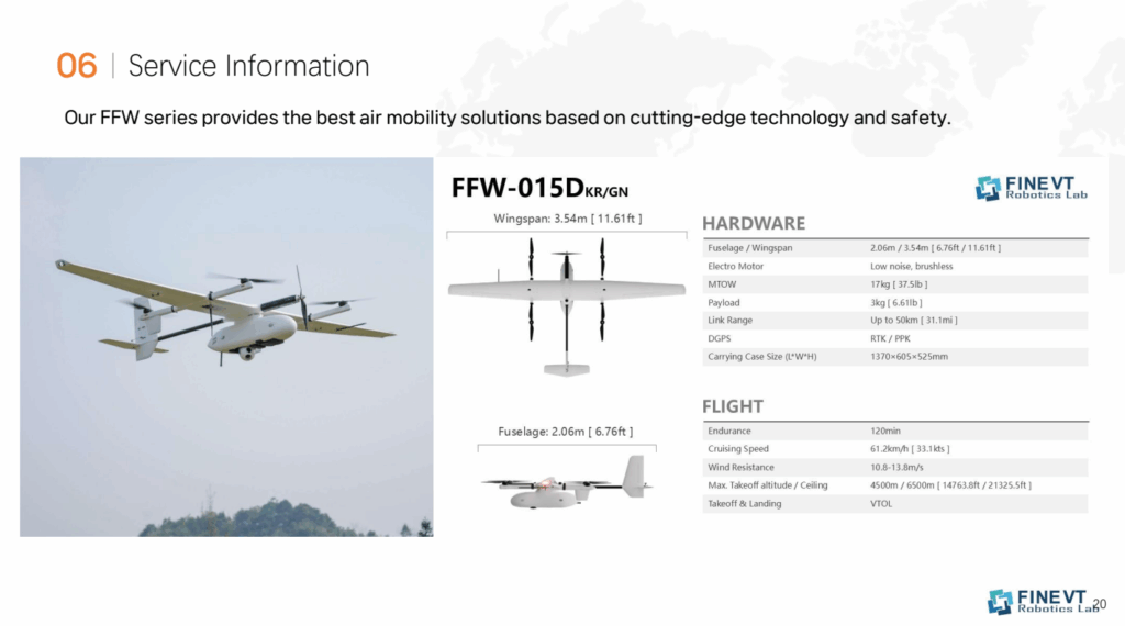
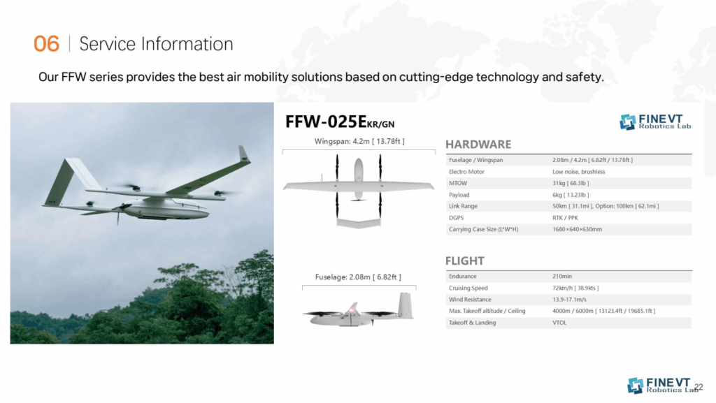
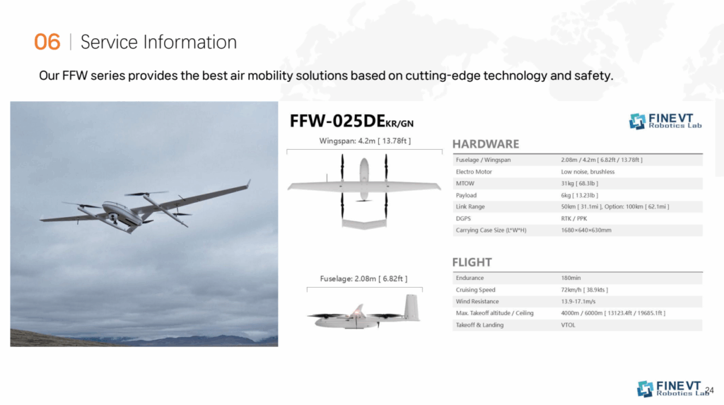
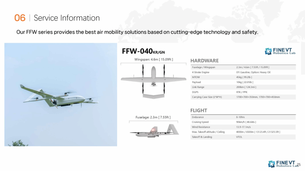
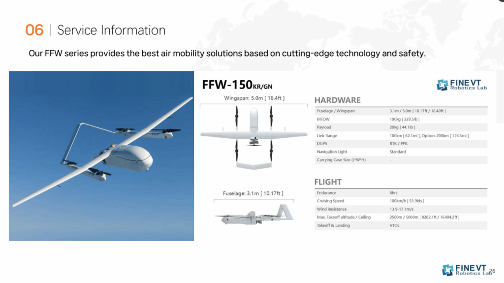
- Configuration: Fixed-wing VTOL (quad-lift + pusher), high-aspect-ratio wing for efficiency.
- Endurance Target: 18–24+ hours (mission-dependent), cruise 60–90 kt, ceiling up to 18,000 ft MSL (airspace-permitting).
- Propulsion: Hybrid-electric with generator for cruise; electric for precision VTOL phases to minimize acoustic footprint.
- Environmental: IP-rated avionics, anti-icing options, modular payload bay (10–15 kg class).
Communications:
- Primary Link: LEO satellite terminal with beam steering and auto-acquisition.
- Secondary Links: LTE/5G (where available), sub-GHz telemetry for contingency, and line-of-sight C2 as tertiary backup.
- Networking: Multi-path bonding, adaptive bitrate streaming, automatic link failover.
Payload Suite (Modular):
- EO/IR Gimbals: Day/night ISR; stabilized imagery with narrow/wide FOV.
- Multispectral/Thermal: Vegetation stress, water delineation, hotspot detection.
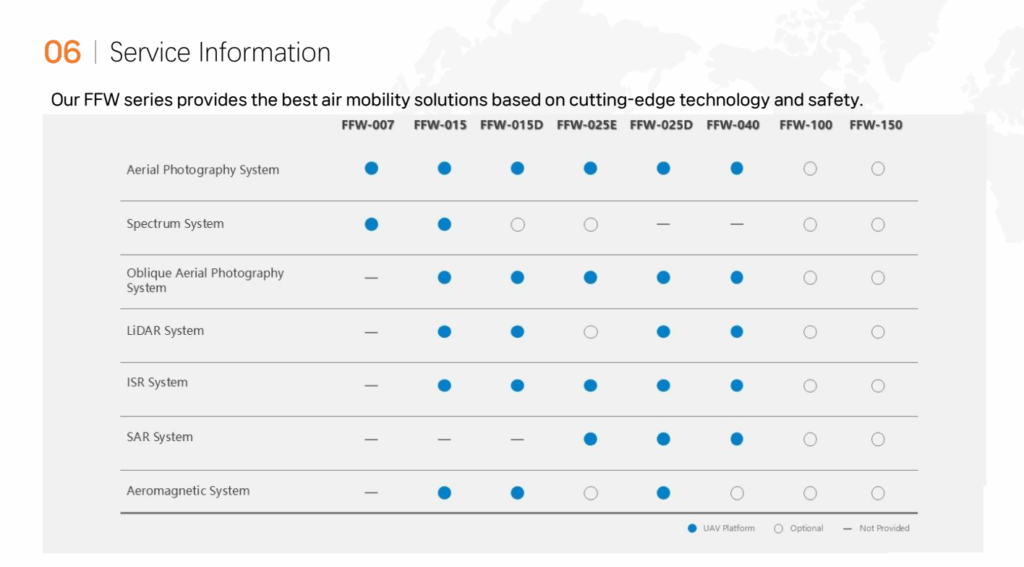
- SAR (Synthetic Aperture Radar) – optional: All-weather, through-smoke/cloud imaging.
- Public Safety Add-ons: Loudspeaker, spotlight, and ADS-B In/Out for traffic awareness.
Autonomy & Safety:
- BVLOS-Ready: GNSS-denied navigation aids (visual-inertial odometry, terrain maps), route replanning.
- DAA: Cooperative (ADS-B) + non-cooperative sensors (radar/EO) for air risk mitigation.
- FMS: Health-aware mission manager, geofencing, return-to-home via safest link.
Edge–Cloud Data Pipeline:
- Onboard Edge AI: Object change detection, smoke/hotspot segmentation, waterline extraction.
- Streaming: STANAG/MPEG-TS/RTSP video over LEO; metadata (MISB/KLV) tagging.
- Cloud Layer: Real-time tiling, orthomosaic generation, anomaly alerts, time-series dashboards, and open APIs for EOC (Emergency Operations Center) tools.
5) Concept of Operations (CONOPS)
- Pre-Mission Planning: Define AOI, regulatory clearances (BVLOS waivers), weather and link budgets.
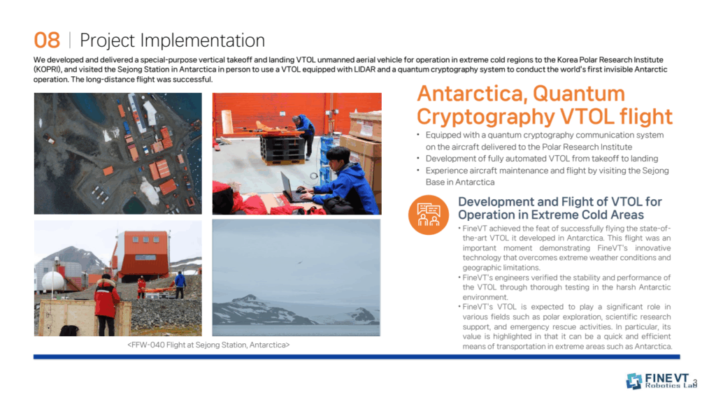
- Launch & Transition: Vertical take-off from improvised sites; transition to fixed-wing cruise for range/endurance.
- Persistent Monitoring: Grid or orbit patterns over AOI; live streams to command centers via LEO backhaul.
- Tasking & Retasking: Cloud UI pushes dynamic task updates; aircraft executes with collision and terrain avoidance.
- Data Exploitation: Automated alerts feed responders; annotated maps shared with inter-agency partners.
- Recovery & Turnaround: Vertical landing near field team; hot-swap payloads and rapid relaunch.
6) Regulatory & Compliance
- United States: FAA Part 107/§44807 pathways and BVLOS waivers; Remote ID; spectrum compliance (FCC).
- International Ops: SORA-based risk assessment; ADS-B equipage where required; privacy & data governance controls.
- Safety Cases: Ground risk buffers, emergency flight termination logic, link-loss behaviors, and ops over people mitigations.
7) Program Timeline (Illustrative)
- Phase 1 (Q3–Q4 2025): Preliminary design review, LEO terminal integration, hardware-in-the-loop tests.
- Phase 2 (Q1–Q2 2026): Flight tests (VTOL transition, endurance), initial BVLOS trials on U.S. test ranges.
- Phase 3 (Q3 2026): Payload integration (EO/IR, multispectral), cloud analytics MVP, inter-agency demo.
- Phase 4 (Q4 2026): Pilot deployments with U.S. and international responders; operational evaluation and scale-up.
8) Performance Targets & KPIs
- Endurance: ≥ 18 hours with EO/IR payload; ≥ 12 hours with SAR payload.
- Coverage: ≥ 1,500 km² per sortie (altitude and sensor-dependent).
- Latency: Sub-3 seconds for low-bandwidth telemetry; sub-10 seconds for adaptive video over LEO.
- Availability: ≥ 99.5% comms uptime (multi-link).
- Detection Metrics: ≥ 90% hotspot recall (wildfire), ≥ 85% flooded-area IoU vs. ground truth (AI pipeline).
- Turnaround: < 30 minutes between sorties with modular battery/fuel service.
9) Risk & Mitigation
- LEO Link Variability: Multi-constellation support, store-and-forward fallback, dynamic bitrate codecs.
- Regulatory Delays: Early engagement with authorities, phased test sites, adherence to ASTM/RTCA standards.
- Energy Density Limits: Hybrid-electric optimization, lightweight composites, drag-reduction planform.
- All-Weather Ops: De-icing options, conformal radome, SAR payload for smoke/cloud penetration.
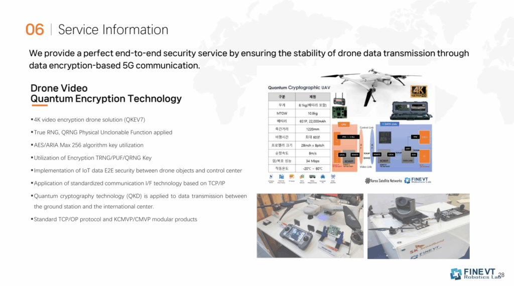
- Cybersecurity: End-to-end encryption, SBOM and vulnerability management, zero-trust cloud access.
10) Partnership & Value for Stakeholders
- Emergency Agencies: Live, resilient situational awareness; interoperable data feeds for EOCs.
- Communities & NGOs: Faster assessments, targeted relief, improved safety for responders.
- Research Partners: Shared datasets, open standards contributions, student training and joint publications.
- Commercial Operators: Scalable platform adaptable to inspection, environmental monitoring, and security.
11) Sustainability & ESG
- Hybrid-Electric Efficiency: Reduced fuel burn vs. conventional fixed-wing UAS.
- Noise-Sensitive VTOL: Quiet operations near communities and wildlife zones.
- Responsible Data: Privacy-by-design, controlled retention, and ethical AI governance.